Data
Solutions
Welcome to
the home of Data Solutions
Developing GIS
solutions for the Mining / Environmental / Wildlife and Fishing industries.
MetaMap
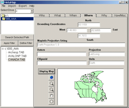
MetaMap is a metadata collection and search tool designed for the management of MapInfo table files. All metadata are collected and displayed in a format based on the Content Standards for Digital Geospatial Metadata, FGDC-STD-001-1998. MetaMap uses a subset of the USGS Federal Geographic Data Committee (FGDC) metadata standards using a simple WHO / WHAT / WHEN / WHERE / WHY / HOW format to present data entry forms to the user. (See USGS Metadata Tools for a complete description of this Metadata in Plain Language concept). Many metadata compilers use subsets of complete profiles to gather a minimum searchable set. The Dublin Core and Denver Core proposals are examples of these. Export to FGDC ASCII format is supported. Simplicity was the main design strategy during the software development process.
Mapinfo
Utilities
If you have comments or suggestions
please send  Mail to Data Solutions.
Copyright © 1998 Data
Solutions. All rights reserved.